Calculated as Production (if any) + Imports - Exports
Community consultations have taken place on four islands to collect relevant information on island biodiversity, so as to incorporate this into the National Biodiversity Strategy and Action Plan. The perceived threats are shown in this excel sheet.
The World Database on Protected Areas (WDPA) is the most comprehensive global database of marine and terrestrial protected areas, updated on a monthly basis, and is one of the key global biodiversity data sets being widely used by scientists, businesses, governments, International secretariats and others to inform planning, policy decisions and management.
The data presents the volume and value of estimates annual fisheries catches and aqua cultural harvest in Tuvalu in 2014.
REST end point for PEIN search results
Data extracted from the Fisheries in PIC's economies' report, 2016.
The apparent changes in production for the three years sometimes represents real change in production, but it can also reflect a change in the methodology for how the production is measured (hopefully an improvement). In table above, the production levels for coastal commercial, coastal subsistence, and freshwater change significantly between the years, but some of that change is due to the way in which the production was estimated. For example, for the 2014 estimate of coastal fisheries production, the results of
the 2010 HIES were available.
As a developing country, Tuvalu is listed under Article 5 of the Montreal Protocol, and therefore provided with assistance to phase-out consumption of CFCs by 2010, HCFCs by 2030, and HFCs by 2024. According to Tuvalu’s 2010 National Compliance Action Strategy (NCAS) to implement the Montreal Protocol, only two types of ODS are known to have been imported into Tuvalu – CFCs and HCFCs, both in very small quantities. All consumption of these substances is through the refrigeration and air conditioning service sector (Government of Tuvalu 2010).
As a developing country, Tuvalu is listed under Article 5 of the Montreal Protocol, and therefore provided with assistance to phase-out consumption of CFCs by 2010, HCFCs by 2030, and HFCs by 2024. According to Tuvalu’s 2010 National Compliance Action Strategy (NCAS) to implement the Montreal Protocol, only two types of ODS are known to have been imported into Tuvalu – CFCs and HCFCs, both in very small quantities. All consumption of these substances is through the refrigeration and air conditioning service sector (Government of Tuvalu 2010).
Tuvalu-related publications on Pacific Environment Information Network (PEIN)
Search using the keyword "Tuvalu". 793 Results as of 15 April, 2018
Long form dataset containing data from APWC high level waste sorts and detailed container sort. See the "Pivot Table" sheet for a summary of the data contained here.
Note that average values will not work for the pivot table, as each category has a number of subcategories which messes up the calculation of averages.
The WDPA User Manual provides information and guidance about the data held within the WDPA, including its history, how it is collected, managed and distributed, and how it should be interpreted and used for analyses and research. The Manual has been prepared for WDPA data providers and users. It is structured in 4 sections and includes 6 appendices.
The Protected Areas Working Group (PAWG) of the Pacific Islands Round Table for Nature Conservation recommended a forum to better connect a diverse range of people and their work relating to protected and conserved areas. To increase efficacy with respect to gaining momentum with communications and conservation work, the Pacific Islands Protected Area Portal (PIPAP) was launched.
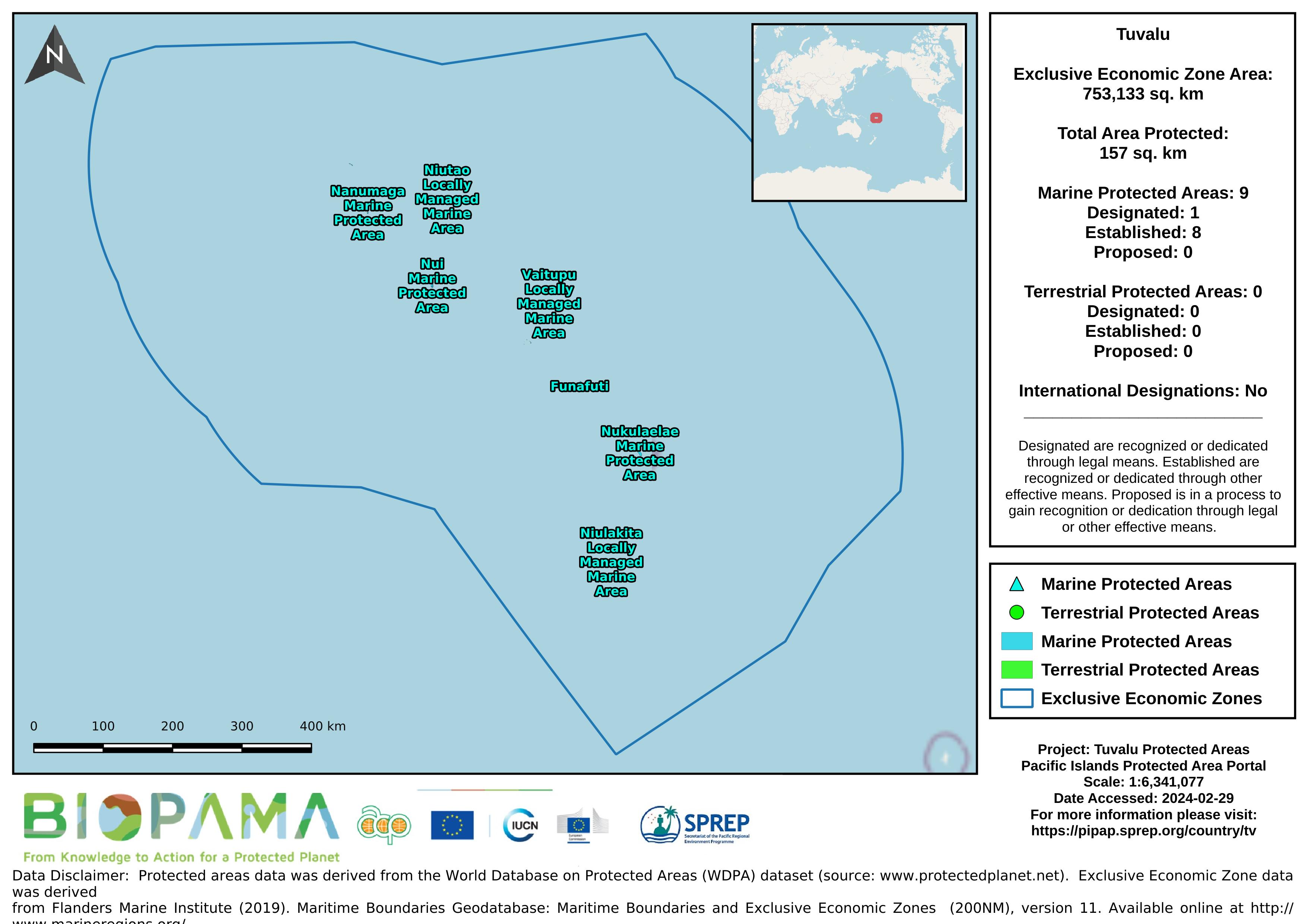
Map of the protected areas for Tuvalu with country-level summary statistics on the amount of area under protection, count for each type of protected area (terrestrial or marine), and the count of their designation.
Forest area for pacific island countries
Reefs at Risk Revisited is a high-resolution update of the original global analysis, Reefs at Risk: A Map-Based Indicator of Threats to the World’s Coral Reefs. Reefs at Risk Revisited uses a global map of coral reefs at 500-m resolution, which is 64 times more detailed than the 4-km resolution map used in the 1998 analysis, and benefits from improvements in many global data sets used to evaluate threats to reefs (most threat data are at 1 km resolution, which is 16 times more detailed than those used in the 1998 analysis).