The Pacific Network for Environmental Assessment (PNEA) Portal is an initiative of the Secretariat of the Pacific Regional Environment Programme (SPREP) to support government officials from Pacific Island countries and territories who work with environmental impact assessment (EIA), strategic environmental assessment (SEA) as well as Environmental and Social Safeguards (ESS).
The portal complements SPREP’s current capacity building program for EIA and SEA - including the recently launched Regional EIA Guidelines, the Coastal Tourism EIA guidelines, and SEA guidelines.
Dataset that provides a direct link to Tuvalu's data hosted on the GBIF website / records.
Tuvalu-related publications on Pacific Environment Information Network (PEIN)
Search using the keyword "Tuvalu". 793 Results as of 15 April, 2018
Concise environmental legislative reviews of Pacific Island countries plus Tokelau. **Please submit new information or corrections as the reviews will be updated annually.**
Forest area for pacific island countries
The Smithsonian Institution's Global Volcanism Program (GVP) is housed in the Department of Mineral Sciences, National Museum of Natural History, in Washington D.C. We are devoted to a better understanding of Earth's active volcanoes and their eruptions during the last 10,000 years.
Reefs at Risk Revisited is a high-resolution update of the original global analysis, Reefs at Risk: A Map-Based Indicator of Threats to the World’s Coral Reefs. Reefs at Risk Revisited uses a global map of coral reefs at 500-m resolution, which is 64 times more detailed than the 4-km resolution map used in the 1998 analysis, and benefits from improvements in many global data sets used to evaluate threats to reefs (most threat data are at 1 km resolution, which is 16 times more detailed than those used in the 1998 analysis).
The USGS Earthquake Hazards Program of the U.S. Geological Survey (USGS) is part of the National Earthquake Hazards Reduction Program (NEHRP) led by the National Institute of Standards and Technology (NIST).
Dataset includes various regional-scale spatial data layers in geojson format.
This dataset holds all media resources for the State of Environment and Conservation in the Pacific Islands: 2020 Regional Report
This article presents an analysis of shoreline change in all 101 islands in the Pacific atoll nation of Tuvalu. Using remotely sensed data, change is analysed over the past four decades, a period when local sea level has risen at twice the global average (~3.90 ± 0.4 mm.yr−1). Results highlight a net increase in land area in Tuvalu of 73.5 ha (2.9%), despite sea-level rise, and land area increase in eight of nine atolls.
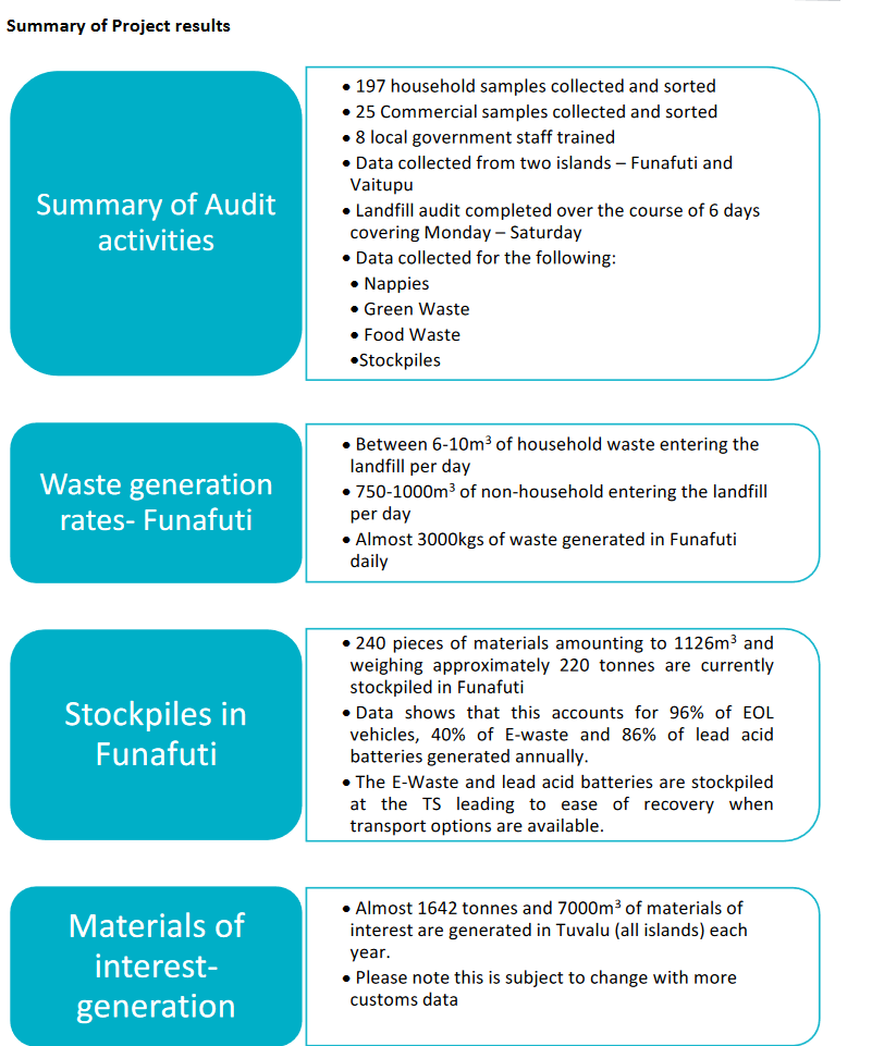
Waste audit and interview data collected by APWC in October 2019.
This publication ‘Strategic Environmental Assessment – Guidelines for Pacific Island Countries and
Territories’ has been prepared to provide guidance on the application of SEA as a tool to support
environmental planning, policy and informed decision making. It provides background on the use and
benefits of SEA as well as providing tips and guiding steps on the process, including case studies, toolkits
and checklists for conducting an SEA in the Appendices.
The results of this analysis challenge perceptions of island loss, showing islands are dynamic features that will persist as sites for habitation over the next century, presenting alternate opportunities for adaptation that embrace the heterogeneity of island types and their dynamics.
Analysis of waste generation and disposal data collected in September 2019