The WDPA User Manual provides information and guidance about the data held within the WDPA, including its history, how it is collected, managed and distributed, and how it should be interpreted and used for analyses and research. The Manual has been prepared for WDPA data providers and users. It is structured in 4 sections and includes 6 appendices.
The Protected Areas Working Group (PAWG) of the Pacific Islands Round Table for Nature Conservation recommended a forum to better connect a diverse range of people and their work relating to protected and conserved areas. To increase efficacy with respect to gaining momentum with communications and conservation work, the Pacific Islands Protected Area Portal (PIPAP) was launched.
Resource contains raster files for a Digital Elevation Model (DEM) and derived hillshade for Tuvalu.
The ASTER Global Digital Elevation Model (GDEM) Version 3 (ASTGTM) provides a global digital elevation model (DEM) of land areas on Earth at a spatial resolution of 1 arc second (approximately 30 meter horizontal posting at the equator).
This resource contains satellite imagery for Tuvalu. The imagery was collected on July 20, 2020, September 21, 2020, and October 11, 2020.
More specially, this resource contains a raster file of RGB imagery at 10-meter resolution, using Level-2A products when available. Level-2A products include atmospheric correction and represent bottom of atmosphere reflectance values in the images. When Level-2A products were not available, Level-1C (top of atmosphere) products were used.
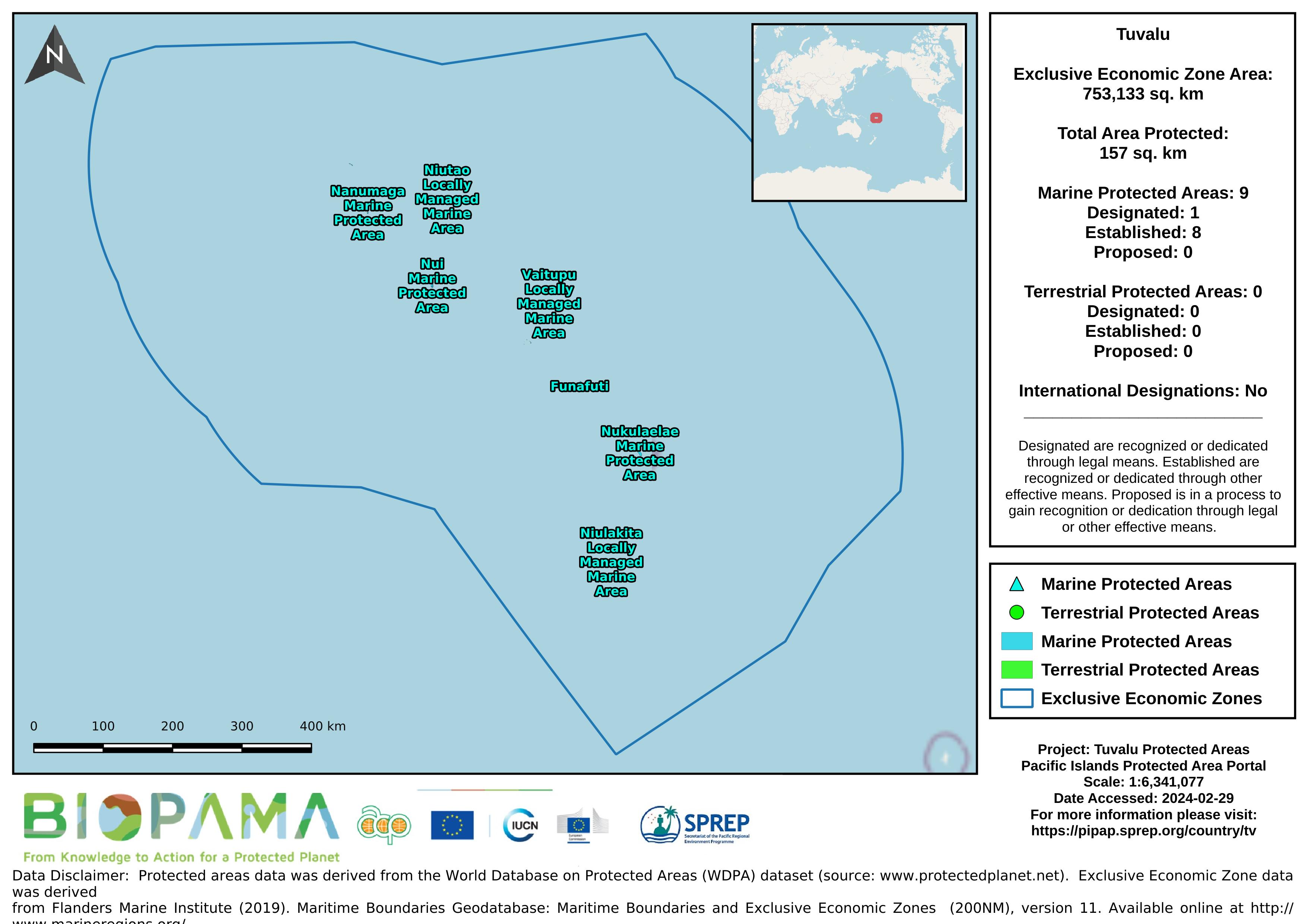
Map of the protected areas for Tuvalu with country-level summary statistics on the amount of area under protection, count for each type of protected area (terrestrial or marine), and the count of their designation.
Map of the protected areas for Tuvalu with country-level summary statistics on the amount of area under protection, count for each type of protected area (terrestrial or marine), and the count of their designation.
direct link to Tuvalu's data on the GBIF website
Pacific islands region land area
direct internet link to Tuvalu's climate change data portal.
**draft only**
Lilie de Tupai ou Motu~Iti (16°15S, 15l°50,W), lun des cinq atolls des lies de la Societe, est, apres Bellingshausen (souvent ecrit Belling- hausen) (15°45S, 154°33W), le plus au nord de cet archipel, a 280 km NNW de Papeete. C'est grace a l'amabilite de son proprietaire, Maltre Marcel Lejeune, et a l'interet qu'il porte aux travaux scientifiques que j'ai
Fruit bats of the genus Pteropus are considered to be strong fliers (Kingdon, 1974; Nowak and Paradiso, 1983), with some species commuting distances of 10-50 km between day roosts and feeding areas (Breadon, 1932; Ferrar, 1934; Hall, 1983; Lim,
1966; McWilliam, 1985-1986; Ratcliffe, 1932; Taylor, 1934; Walton and Trowbridge, 1983). Longer seasonal movements of > 100 km are known for several species of Australian Pteropus, which change roosting sites in response to shifting patterns in the
This report presents a set of indicators, referred to as the 'core' set. for reporting on the state of the environment across Commonwealth and State and Territory jurisdictions. The core indicators have been developed by the Australian and New Zealand Environment and Conservation Council (ANZECC) through an extensive consultation process involving both government agencies and the general public.
This new set of 60 indicator icons can be used in a State of Environment report to indicate the status of environmental issues and progress in a country.
Zip file contains a video explaining how to add a resource for logged-in users.
Zip file contains a video explaining how to create a visualization for logged-in users.
Zip file contains a video explaining how to add a group and user for logged-in users.
Each value represents the number of dumping events observed on fishing vessels during the period 2003-2015