Greenhouse Gas Emission - Of the total 2014 emissions of 18.467 Gg CO2-e, 11.214 Gg (61%) can be attributed to the energy sector. The main GHGs emitted by Tuvalu are CO2 (60.4% of total emissions), CH4 (16.4%), and N2O (23.1%)
Trends in ODS Consumption - As a developing country, Tuvalu is listed under Article 5 of the Montreal Protocol, and therefore provided with assistance to phase-out consumption of CFCs by 2010, HCFCs by 2030, and HFCs by 2024.
As a developing country, Tuvalu is listed under Article 5 of the Montreal Protocol, and therefore provided with assistance to phase-out consumption of CFCs by 2010, HCFCs by 2030, and HFCs by 2024. According to Tuvalu’s 2010 National Compliance Action Strategy (NCAS) to implement the Montreal Protocol, only two types of ODS are known to have been imported into Tuvalu – CFCs and HCFCs, both in very small quantities. All consumption of these substances is through the refrigeration and air conditioning service sector (Government of Tuvalu 2010).
Long form dataset containing data from APWC high level waste sorts and detailed container sort. See the "Pivot Table" sheet for a summary of the data contained here.
Note that average values will not work for the pivot table, as each category has a number of subcategories which messes up the calculation of averages.
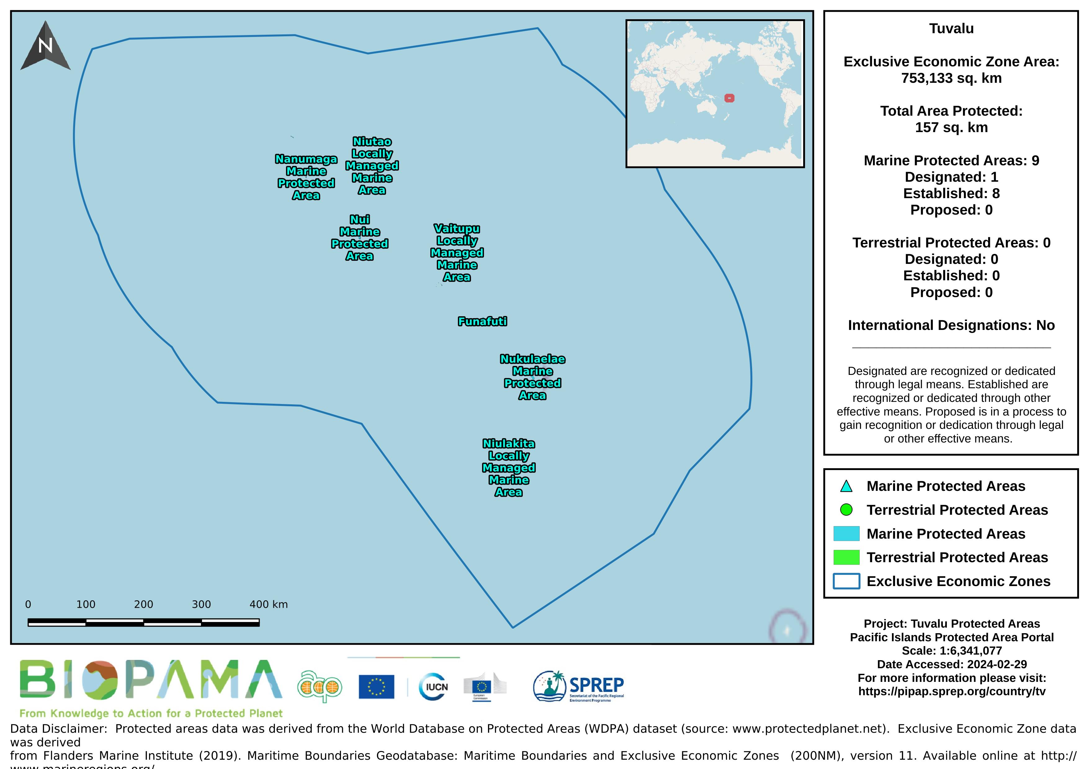
Map of the protected areas for Tuvalu with country-level summary statistics on the amount of area under protection, count for each type of protected area (terrestrial or marine), and the count of their designation.
Forest area for pacific island countries
gis file with points on pollution incidents in the Solomon Islands
Reefs at Risk Revisited is a high-resolution update of the original global analysis, Reefs at Risk: A Map-Based Indicator of Threats to the World’s Coral Reefs. Reefs at Risk Revisited uses a global map of coral reefs at 500-m resolution, which is 64 times more detailed than the 4-km resolution map used in the 1998 analysis, and benefits from improvements in many global data sets used to evaluate threats to reefs (most threat data are at 1 km resolution, which is 16 times more detailed than those used in the 1998 analysis).
The USGS Earthquake Hazards Program of the U.S. Geological Survey (USGS) is part of the National Earthquake Hazards Reduction Program (NEHRP) led by the National Institute of Standards and Technology (NIST).
Metadata file for the GIS data (raster and shapefiles) for the global threats to coral reefs: acidification, future thermal stress, integrated future threats, and past thermal stress.
Metadata file for the GIS data (raster and shapefiles) for the local threats to coral reefs: coastal development, integrated local, marine pollution, overfishing, and watershed pollution.
GeoJSON file for earthquake centers over a magnitude of 4.5 for the Pacific Islands Region for years 2000-2004. Data are derived from the ANSS Comprehensive Earthquake Catalog (ComCat). ComCat contains earthquake source parameters (e.g. hypocenters, magnitudes, phase picks and amplitudes) and other products (e.g. moment tensor solutions, macroseismic information, tectonic summaries, maps) produced by contributing seismic networks.
GeoJSON file for earthquake centers over a magnitude of 4.5 for the Pacific Islands Region for years 2005-2009. Data are derived from the ANSS Comprehensive Earthquake Catalog (ComCat). ComCat contains earthquake source parameters (e.g. hypocenters, magnitudes, phase picks and amplitudes) and other products (e.g. moment tensor solutions, macroseismic information, tectonic summaries, maps) produced by contributing seismic networks.
GeoJSON file for earthquake centers over a magnitude of 4.5 for the Pacific Islands Region for years 2010-2014. Data are derived from the ANSS Comprehensive Earthquake Catalog (ComCat). ComCat contains earthquake source parameters (e.g. hypocenters, magnitudes, phase picks and amplitudes) and other products (e.g. moment tensor solutions, macroseismic information, tectonic summaries, maps) produced by contributing seismic networks.
GeoJSON file for earthquake centers over a magnitude of 4.5 for the Pacific Islands Region for years 2015-2019. Data are derived from the ANSS Comprehensive Earthquake Catalog (ComCat). ComCat contains earthquake source parameters (e.g. hypocenters, magnitudes, phase picks and amplitudes) and other products (e.g. moment tensor solutions, macroseismic information, tectonic summaries, maps) produced by contributing seismic networks.
Pacific islands region exclusive economic zones (EEZs)