Atlas of Living Australia data on invasive alien species in Tuvalu
In a unique move Tokelau requested all regional and international organizations that it is affiliated to either through full membership, associate or by accessing through regional international projects, to visit and consult Tokelau as a "body corporate" or all at once. The intention is to assist a small tiny country in managing all the possible assistance available from these organizations so that the actual assistance itself could be much more effective in their delivery and avoid duplication.
Available online
Call Number: [EL]
Zip file contains a video explaining how to add a dataset for logged-in users
Zip file contains a video explaining how to add additional information for logged-in users.
Zip file contains a video demonstrating a national data portal.
This zip-file contains the setup file to install QGIS software version 3.4, for a 32 bit system.
Atlas of Living Australia data on invasive alien species found in Tuvalu
EIA Amend Regulation that include Social Safeguard System
This dataset contains mapping information (shapefile) of reefs in Tuvalu including its distribution. A foundation baseline map for future, more detailed, work.
Link to download a zip file containing OSM spatial files, a QGIS project, styles, license file and documentation on how to get started.
This dataset contains mapped point locations for protected areas within Tuvalu. This dataset should be viewed in combination with the World Database on Protected Areas polygon locations to get a comprehensive view of all protected areas within Tuvalu.
This dataset contains mapped polygon locations for protected areas within Tuvalu. This dataset should be viewed in combination with the World Database on Protected Areas point locations to get a comprehensive view of all protected areas within Tuvalu.
Resource contains raster files for a Digital Elevation Model (DEM) and derived hillshade for Tuvalu.
The ASTER Global Digital Elevation Model (GDEM) Version 3 (ASTGTM) provides a global digital elevation model (DEM) of land areas on Earth at a spatial resolution of 1 arc second (approximately 30 meter horizontal posting at the equator).
This resource contains satellite imagery for Tuvalu. The imagery was collected on July 20, 2020, September 21, 2020, and October 11, 2020.
More specially, this resource contains a raster file of RGB imagery at 10-meter resolution, using Level-2A products when available. Level-2A products include atmospheric correction and represent bottom of atmosphere reflectance values in the images. When Level-2A products were not available, Level-1C (top of atmosphere) products were used.
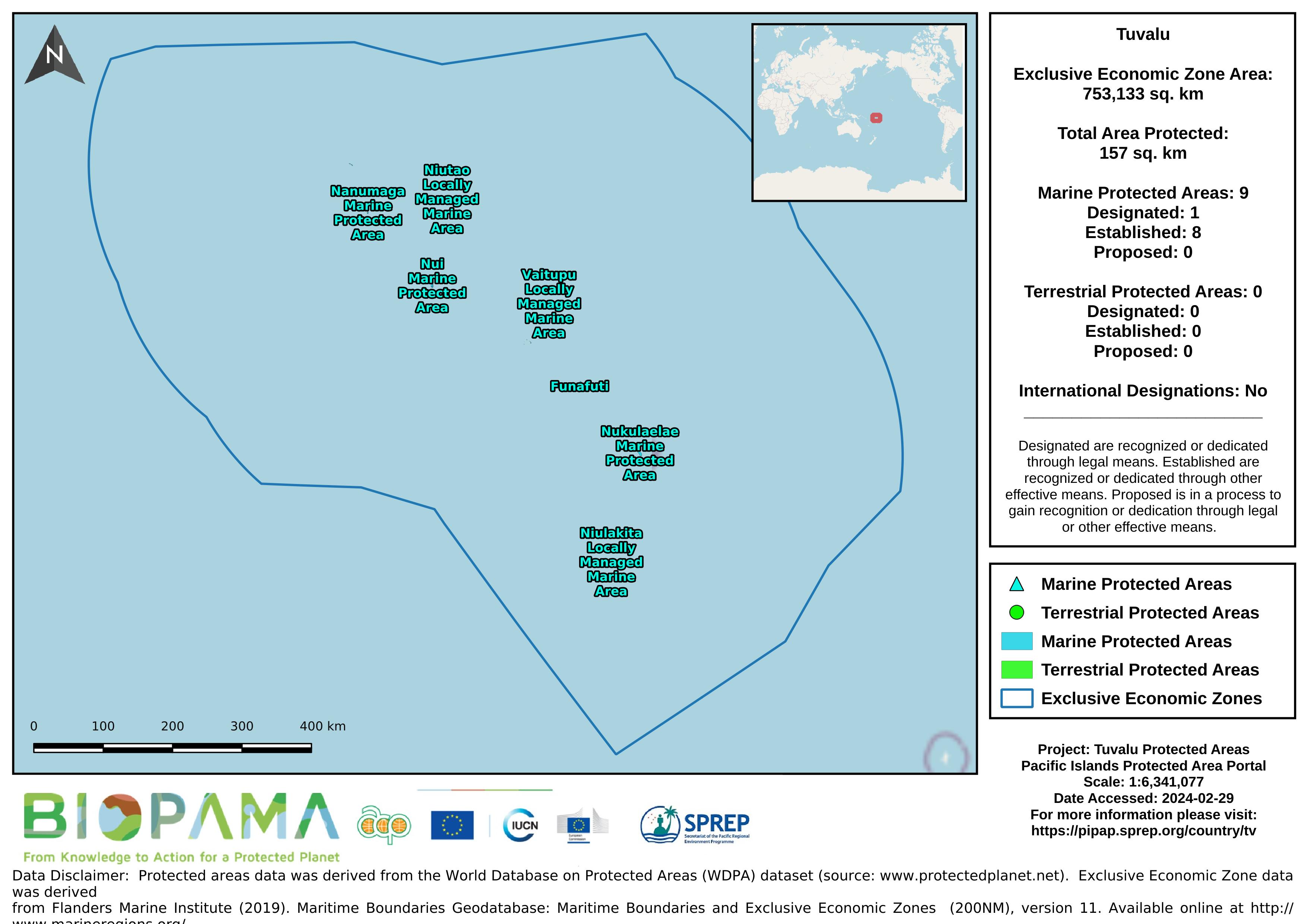
Map of the protected areas for Tuvalu with country-level summary statistics on the amount of area under protection, count for each type of protected area (terrestrial or marine), and the count of their designation.
This new set of 60 indicator icons can be used in a State of Environment report to indicate the status of environmental issues and progress in a country.
Zip file contains a video explaining how to add a resource for logged-in users.