As a developing country, Tuvalu is listed under Article 5 of the Montreal Protocol, and therefore provided with assistance to phase-out consumption of CFCs by 2010, HCFCs by 2030, and HFCs by 2024. According to Tuvalu’s 2010 National Compliance Action Strategy (NCAS) to implement the Montreal Protocol, only two types of ODS are known to have been imported into Tuvalu – CFCs and HCFCs, both in very small quantities. All consumption of these substances is through the refrigeration and air conditioning service sector (Government of Tuvalu 2010).
Long form dataset containing data from APWC high level waste sorts and detailed container sort. See the "Pivot Table" sheet for a summary of the data contained here.
Note that average values will not work for the pivot table, as each category has a number of subcategories which messes up the calculation of averages.
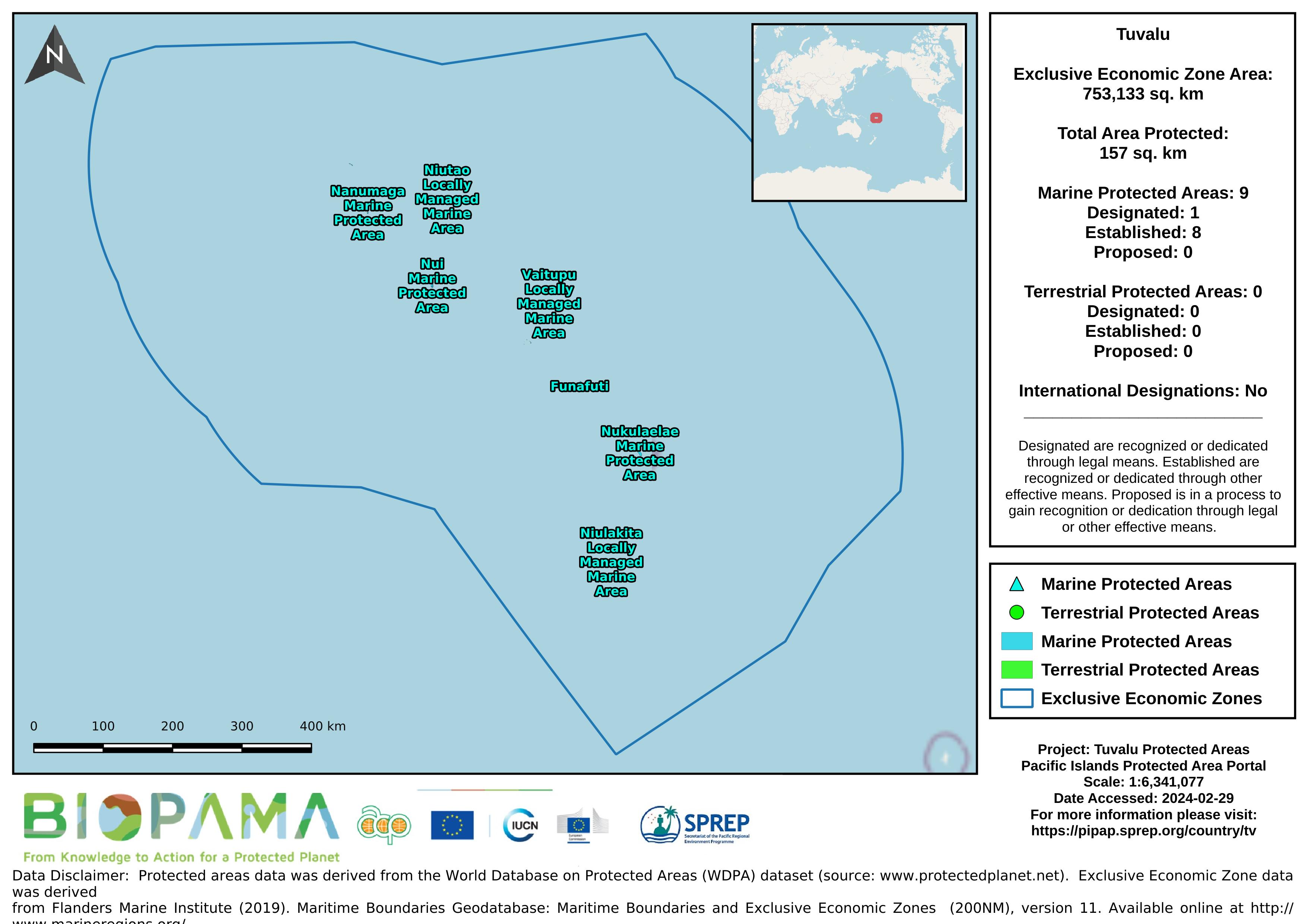
Map of the protected areas for Tuvalu with country-level summary statistics on the amount of area under protection, count for each type of protected area (terrestrial or marine), and the count of their designation.
Forest area for pacific island countries
A direct internet link to and resources pertaining the Blue Habitat website which has been established as a portal for information on the global distribution of marine ‘blue’ habitats. Knowledge on the distribution of blue habitats is an important input into ocean management, marine spatial planning and biodiversity conservation.
Dataset regarding 'Seamounts' - peaks that rise over 1,000 m above the seafloor. Seamount chains occur in all three major ocean basins, with the Pacific having the most number and most extensive seamount chains.
a mapping representation of active and passive continental margins, oceanic plate boundaries and mid ocean spreading ridges
statistical records as of 2014 on the distribution of seamount. Accordingly, there are more seamounts in the Pacific Ocean than in the Atlantic, and their distribution can be described as comprising several elongate chains of seamounts superimposed on a more or less random background distribution (Craig and Sandwell)
This is a template that can be used when creating a State of Environment report, and sections can be added or adapted to fit a country’s needs.
SPREPs recommended template for individual indicators in national SoE reports. The full SoE template will be updated in the coming months.
A collection of Inform project training materials. You are free to download and use any of the training resources below. The PowerPoint presentations contain a complete set of slides, so please feel free to copy, delete or change slides, to fit the purpose of your country training.
This dataset contains templates of policies and MoU's on data sharing.
You can download the Word-templates and adapt the documents to your national context.
At the end of a training, you can ask participants to fill in this Action Plan. The goal is to link learning to performance.
This policy applies requests for data held by a Ministry. The purpose of this policy is to:
• encourage the free exchange of data within a Ministry, with other government agencies within the country and with the public, as appropriate
• ensure that sensitive information (including commercially sensitive data) held by the Ministry is not compromised.
Memorandum of Understanding between two parties, for the exchange of data, related information and other services.
Memorandum of Understanding between SPREP and a Country, to facilitate the access to, and security of, all data entered into the national database.
Reefs at Risk Revisited is a high-resolution update of the original global analysis, Reefs at Risk: A Map-Based Indicator of Threats to the World’s Coral Reefs. Reefs at Risk Revisited uses a global map of coral reefs at 500-m resolution, which is 64 times more detailed than the 4-km resolution map used in the 1998 analysis, and benefits from improvements in many global data sets used to evaluate threats to reefs (most threat data are at 1 km resolution, which is 16 times more detailed than those used in the 1998 analysis).