Click to access a story on Tuvalu's Environmental issues.
A timeline of events, highlighting Tuvalu's participation in the UN since it became a member,
As a developing country, Tuvalu is listed under Article 5 of the Montreal Protocol, and therefore provided with assistance to phase-out consumption of CFCs by 2010, HCFCs by 2030, and HFCs by 2024. According to Tuvalu’s 2010 National Compliance Action Strategy (NCAS) to implement the Montreal Protocol, only two types of ODS are known to have been imported into Tuvalu – CFCs and HCFCs, both in very small quantities. All consumption of these substances is through the refrigeration and air conditioning service sector (Government of Tuvalu 2010).
The web-page has navigation tools for the user to efficiently explore and discover different marine life information for Tuvalu
The online database has a navigation tool to efficiently explore fish information for Tuvalu.
As a developing country, Tuvalu is listed under Article 5 of the Montreal Protocol, and therefore provided with assistance to phase-out consumption of CFCs by 2010, HCFCs by 2030, and HFCs by 2024. According to Tuvalu’s 2010 National Compliance Action Strategy (NCAS) to implement the Montreal Protocol, only two types of ODS are known to have been imported into Tuvalu – CFCs and HCFCs, both in very small quantities. All consumption of these substances is through the refrigeration and air conditioning service sector (Government of Tuvalu 2010).
video presented by a representative of Tuvalu explaining briefly the importance of the Inform Project
Dataset that provides a direct link to Tuvalu's data hosted on the GBIF website / records.
Tuvalu-related publications on Pacific Environment Information Network (PEIN)
Search using the keyword "Tuvalu". 793 Results as of 15 April, 2018
Dataset that provides a direct internet link to Tuvalu's climate change data portal.
Long form dataset containing data from APWC high level waste sorts and detailed container sort. See the "Pivot Table" sheet for a summary of the data contained here.
Note that average values will not work for the pivot table, as each category has a number of subcategories which messes up the calculation of averages.
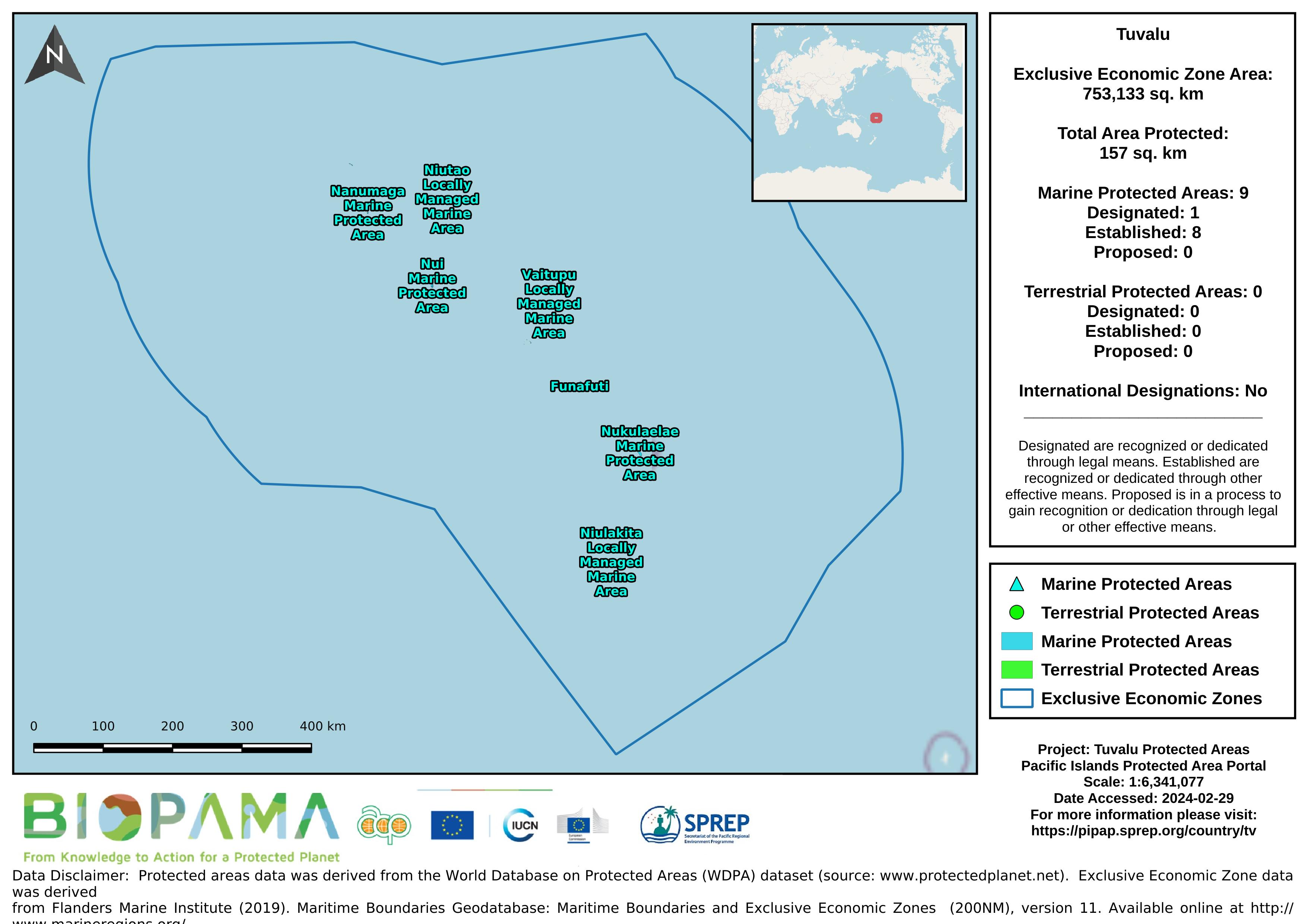
Map of the protected areas for Tuvalu with country-level summary statistics on the amount of area under protection, count for each type of protected area (terrestrial or marine), and the count of their designation.
direct link to Tuvalu's data on the GBIF website
direct internet link to Tuvalu's climate change data portal.
Forest area for pacific island countries
Bio-ORACLE is a set of GIS rasters providing geophysical, biotic and environmental data for surface and benthic marine realms. The data are available for global-scale applications at a spatial resolution of 5 arcmin (approximately 9.2 km at the equator).
Linking biodiversity occurrence data to the physical and biotic environment provides a framework to formulate hypotheses about the ecological processes governing spatial and temporal patterns in biodiversity, which can be useful for marine ecosystem management and conservation.
Reefs at Risk Revisited is a high-resolution update of the original global analysis, Reefs at Risk: A Map-Based Indicator of Threats to the World’s Coral Reefs. Reefs at Risk Revisited uses a global map of coral reefs at 500-m resolution, which is 64 times more detailed than the 4-km resolution map used in the 1998 analysis, and benefits from improvements in many global data sets used to evaluate threats to reefs (most threat data are at 1 km resolution, which is 16 times more detailed than those used in the 1998 analysis).