Concise environmental legislative reviews of Pacific Island countries plus Tokelau. **Please submit new information or corrections as the reviews will be updated annually.**
Dataset includes various regional-scale spatial data layers in geojson format.
This dataset holds all media resources for the State of Environment and Conservation in the Pacific Islands: 2020 Regional Report
This academic paper investigates the vulnerability of households to climatic disasters in the low-lying atoll nation of Tuvalu. Using the most recent household surveys available, the authors constructed poverty and hardship profiles for households on the different islands of Tuvalu, and combine these with geographic and topographic information to assess the exposure differentials among different groups using spatial econometric models.
The map is a fundamental tool for local resident and island management. It was constructed by latest and high-resolution satellite images and the measured results of field investigation by Foram Sand Project, J-PACE and SOPAC.
This study addresses rainfall trends, the frequency of droughts, La Niña influences and the relationship between rainfall and Sea Surface Temperature (SST) in Tuvalu. The findings revealed that;
* de-trended rainfall time series show declining trends in all four rainfall stations over the period 1953-2012;
* the frequency of drought ranges from three to fourteen years with a mean of nine years
* the occurrence of drought appears to follow the La Niña years
* boplots provide an effective option for defining drought
Tuvalu’s environment is under pressure: sea-water rise contaminating the soil with salt, direct impact on waste and sewage systems from rising human density contributing to further damage. The 1987 UN Brundlandt report has definitely shown the existing link between environment/ecology and development /economy. Tomorrow’s economy stems from today’s environment.
This publication ‘Strategic Environmental Assessment – Guidelines for Pacific Island Countries and
Territories’ has been prepared to provide guidance on the application of SEA as a tool to support
environmental planning, policy and informed decision making. It provides background on the use and
benefits of SEA as well as providing tips and guiding steps on the process, including case studies, toolkits
and checklists for conducting an SEA in the Appendices.
Besides the observation that poor households are more vulnerable to negative shocks because they lack the resources to respond, the study also find that they are also more likely to reside in areas highly exposed to disasters (closer to the coasts and at lower elevation) and have less ability to migrate (between and within the islands).
All contents described in the printed map are included in the digital data set which is constructed by Arc/GIS.
Addressing rainfall trends, the frequency of droughts, La Niña influences and the relationship between rainfall and Sea Surface Temperature (SST) in the small Pacific country of Tuvalu.
Tuvalu’s environment is under pressure: sea-water rise contaminating the soil with salt, direct impact
on waste and sewage systems from rising human density contributing to further damage. The 1987 UN
Brundlandt report has definitely shown the existing link between environment/ecology and
development /economy. Tomorrow’s economy stems from today’s environment. Investing in the
quality of soil, avoiding water pollution, protecting natural resources especially energy sources as well
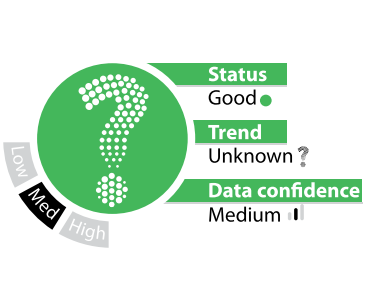
This first state of the environment report for the Pacific region uses regional environment indicators to assess the status, trends, and data quality and availability for the endorsed Pacific environmental priorities. This report also includes an update of the State of Conservation in Oceania report produced in 2013, which was endorsed and published in 2017.
This dataset hosts 31 individual environmental indicator assessments that are in the **State of Environment and Conservation in the Pacific Islands : 2020 Regional report.**
Regional indicators are used to understand the current status of conservation in the region and to establish a process for periodic reviews of the status of biodiversity and implementation of environmental management measures in the Pacific islands region.
Each Pacific regional indicator is assessed with regard to:
In this report, a set of recommendations is provided for each indicator to support the next best steps for management action that will advance progress towards the target outcome and support Pacific people and biodiversity.
**This pdf combines all 31 indicators in one document**
DEFINITION - % of national budget allocated to Environment Ministry or equivalent
PURPOSE - Determine trends in prioritisation of environmental funding within government
DESIRED OUTCOME - Stable or positive trend; sufficient and sustainable financing to implement environmental programmes